Arctic National Wildlife Refuge – I was standing in the back of the sled when it broke through the ice, plunging into the frigid water of the Hulahula River. Just in time, Robert yanked the machine. The heavy sled, instead of falling on me, gradually moved out of the shallow water. It must have been about 40 degrees below zero. I began to settle into hypothermia. Robert Thompson and his cousin Perry Anashugak quickly set up the tent and lit both burners of the Coleman stove. Inside a sleeping bag, I began to warm up. That day, I escaped death, barely. “The river is supposed to have solid ice on the surface in November, not fragile like this,” Robert lamented. That was 2001, in the Arctic National Wildlife Refuge (NWR) in northeast Alaska.
Five months before the Hulahula River incident, in mid-June, Robert and I were standing on the northern edge of Barter Island. In front of us was Barnard Harbor that extends to a barrier island, which meets the Beaufort Sea. On the south was the coastal plain of the Arctic NWR. A short distance away a mid-sized polar bear was approaching a whale bone left behind from the previous year’s hunt by the Iñupiat people of Kaktovik. The sea ice on the harbor was still frozen, but the snow on top was beginning to melt, creating puddles. There was no wind, and the evening sun was casting a warm glow on the white seascape and on the ivory fur of the bear. As the bear walked past one of the puddles, I noticed a perfect reflection and clicked the shutter. In 2001, almost no one, including the biologists, anticipated what was to happen to the bears of the Beaufort Sea.
Dialing the clock back a bit further to April, Robert and I were traveling through the Canning River Valley in the western edge of the Arctic NWR, when we came across a band of 13 muskoxen with a newborn calf, likely a day or two old. The woolly bovines were migrating from the foothills of the Brooks Range Mountains to the coastal plain. Muskoxen, one of the most adapted animals to the extreme cold of the Arctic, give birth on exposed land when the ground is covered with snow and temperatures dip way below freezing. A few hours after the sighting, a strong blizzard started to blow, the temperature around 35 below zero with windchills approaching minus 100 degrees Fahrenheit. Robert thought it was “unusual” that the band of muskoxen with a newborn calf would migrate like that.
Harbingers
These incidents constitute a starting point, showing how varieties of environmental changes have arrived in a rather short time, since the turn of the 21st century, in a particular place—each representative of the many significant climate change impacts that affect the human communities and the nonhuman biotic life in the entire circumpolar Arctic. When land and sea are going through rapid changes, inhabitants of the area are usually the first to witness it. In 2002, the Arctic Research Consortium of the United States, in cooperation with the Arctic Studies Center of the Smithsonian Institution, pointed out that the indigenous peoples “are already witnessing disturbing and severe climatic and ecological changes,” even though “the majority of the Earth’s citizens have not seen any significant climate changes thus far.” Thirteen years later, a majority of the world’s people are experiencing significant impacts of climate change. In the Arctic, the changes have only accelerated.
Iñupiaq conservationist Robert Thompson and his wife Jane live in Kaktovik, a small town of about 300 residents on Barter Island. A decade ago, the conversations I had with residents of Kaktovik and Arctic Village focused on both climate change and oil development. The lakes were drying up, affecting subsistence fishing. The willow plants were getting much larger and bushier affecting migration of caribou. And wildfires were becoming widespread and more destructive. All this came from the Gwich’in people, while the Iñupiat people said the sea ice was retreating rapidly and the permafrost was beginning to thaw.
In early August 2006, at the northwestern edge of Barter Island, a coffin was lying exposed with bones scattered nearby. The permafrost around the coffin had thawed. Robert told me in an email:
The grave we saw on the other side of the island was of a child. Lon Sonsalla, Fenton Rexford, and I went over there when we heard that a brown bear had broken into the coffin and scattered the body. I picked up a foot. It startled me—it was so light, freeze-dried. We put all the parts back in the box, nailed it shut, and reburied the person. There are two other exposed graves with dates of 1932. These had names and dates cut out of sheet lead; snow had eroded the wood to where the lead was in relief. We also found a wooden marker with a non-native name over by Sungiksaluk, perhaps a whaler. There was also a body that came out of the ground to the east. It was reburied in our cemetery.
The Arctic is warming at a rate of at least twice the global average. With this rapid warming, permafrost, or permanently frozen ground, is thawing. When permafrost thaws, the organic matter inside begins to break down and releases carbon dioxide and methane, the latter about 86 times more potent than carbon dioxide, as a greenhouse gas over a 20-year period. One of the most visible signs of thawing permafrost is “drunken forest”—trees leaning at odd angles as they lose their footing in the unstable soil. In November 2007, large areas of drunken forest were spreading near Nelemonoye, a Yukaghir community along the upper Kolyma River in the Sakha Republic. Thawing of terrestrial permafrost also has major impact on ecology, hydrology, and human infrastructures, as homes, buildings, roads, and runways can collapse as the ground underneath begins to buckle.
In addition to carbon stored in the organic matter inside permafrost, there is also an enormous amount of methane trapped inside icy crystals known as clathrates. Scientists do not yet know how much clathrate is in the Arctic but think that much of the carbon stored in the Arctic is inside clathrates, which can be found either deep in terrestrial permafrost or beneath Arctic shelves offshore, according to a U.S. National Research Council Report. The release of methane from terrestrial permafrost is a slower process, but from subsea permafrost it can happen steadily, or in sudden, potentially catastrophic, pulses. More than a decade of research by Russian scientists Natalia Shakhova and Igor Semiletov shows that methane is being actively released from subsea permafrost in the East Siberian Arctic Shelf. Based on their field observations, a team of physical and social scientists in Europe have shown that a decade-long 50-gigaton methane pulse from the East Siberian Arctic Shelf could cost the global economy an average of $60 trillion. To put this in perspective, the financial damage from just one extreme storm, Hurricane Sandy that hit the East Coast of the United States in 2012, was barely $60 billion. So the aggregate impact on property, infrastructure, and food production of a 50-gigaton methane pulse would be equivalent to 1,000 Hurricane Sandys.
“I was rained on in February,” Robert said speaking of an experience he had in winter 2006. “To me, an Iñupiaq, residing on the edge of the Arctic Ocean, to be rained on in February is strange.” In the winter of 2005 to 2006, a thousand caribou from the Teshekpuk Lake herd came over to the Arctic NWR, a 240-mile journey. “It rained and then the tundra froze over there, and the animals came over to our area to find food,” Robert recalled. “But it also rained on Barter Island, and the tundra froze. I saw some caribou curled up. I thought they were sleeping.”
Robert approached them, thinking “it’s strange that they wouldn’t be more alert. They weren’t because they were dead. The animals could not find food and instead ingested ice and died of hypothermia, a biological study later revealed. Several hundred caribou died on the island that winter. People had to remove the dead animals from the watershed of our freshwater lake so it would not get contaminated.”
Deadly Ice on the Tundra
One of the most significant impacts of Arctic warming on tundra animals in recent years has been rain during autumn and winter months, followed by freezing temperatures that create a hard layer of ice on tundra that animals like caribou or reindeer and muskoxen cannot break through to find food. Earlier this year, Kim Holmén, the international director of the Norwegian Polar Institute told a Guardian reporter that, “Much of Svalbard is covered with ice on land, which is a fatal state for the reindeer,” while the fjords around Svalbard remained unfrozen. Holmén further said that they are experiencing “more icing events,” and when that happens the reindeer “can’t move around, and they can’t eat.”
University of Gothenberg Professor Tyrone Martinsson first went to Svalbard in 2001. He circumnavigated Svalbard that summer at 80 degrees North latitude and was surprised to find “no sea ice in the Arctic Ocean around Svalbard.” He focused his research on the melting of glaciers in Svalbard. In Sweden, an Arctic country with no coastline along the Arctic Ocean, two prominent areas of climate change research are the rapid melting of glaciers that is redefining the highest peaks of Sweden, as well as climate change impacts on the Saami reindeer herders in northern Sweden.
The increased precipitation and icing on tundra also contributed to the disappearance of muskoxen from the Arctic NWR coastal plain. The muskoxen, which once had a circumpolar distribution during the Pleistocene era from 11,700 to 2.5 million years ago, were exterminated from the North Slope of Alaska, including the Arctic NWR, after commercial whalers arrived there with guns in the 19th century. In 1969 and 1970, 51 muskoxen from Nunivak Island were reintroduced to Barter Island. The population increased steadily, reaching almost 350 animals in the Refuge by mid-1990. Then it began to decline. They once lived year-round in the coastal plain of the Refuge, and were considered an iconic species of the coastal plain. In recent years, deeper snow and icing made foraging for food difficult, which resulted in starvation and low calf production. The animals would then move to the foothills to find food on windblown ridges. But when muskoxen give birth in April, grizzly bears would wake up from hibernation in the same area. The muskoxen became an easy prey. So adult animals with newborn calfs moved from the foothills to the coastal plain—to avoid their predators. The last official estimate of muskoxen in the Refuge was 29 animals in 2003. It is generally believed that the number is zero today, although some of the animals moved east and west of the Refuge. This could be considered a case of local extermination caused by a warming Arctic. There are other areas in the Arctic, however, where muskoxen are surviving: more than 100,000 animals in the Canadian Arctic and about 10,000 each in Greenland and Russia. Muskoxen and caribou or reindeer are the only Arctic hoofed animals that made it from the Pleistocene era to modern times, but remain vulnerable to Arctic warming today.
Even though thawing of terrestrial permafrost and icing on tundra are taking place on land affecting humans and nonhuman biotic life, the primary contributor to these changes is to be found in the warming Arctic seas—the rapid retreat of sea ice.
Disappearing Bear and Man
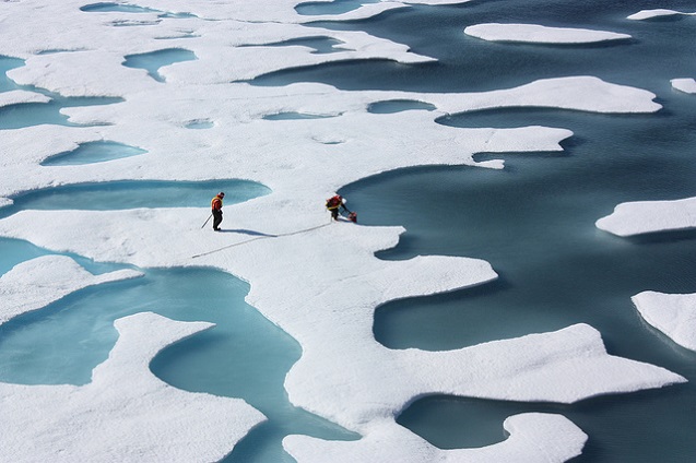
Between 2001 and 2010, the polar bear population in the southern Beaufort Sea region declined by 40 percent. Polar bears critically depend on sea ice for finding food and mates, as well for transport and building offshore dens. But the Arctic sea ice is vanishing at an astonishing rate. Since recording began in 1978, the extent of summer sea ice in the Arctic Ocean has been declining steadily. Though it accelerated after the turn of the 21st century, by August 2007, more than a month before the end of the melt season, a new record low for the minimum sea ice extent was reached—1.7 million square miles, followed by lower yet, in 2012, some 1.16 million square miles, which is nearly half of the 1979-2000 average of 2.7 million square miles. The thickness of Arctic sea ice also declined 65 percent between 1975 and 2012. On February 25, 2015, the winter maximum Arctic sea ice extent hit a record low, and it too arrived nearly two weeks before a usual early March date. As the white surface of the ice is replaced by the dark surface of water, more solar radiation gets absorbed rather than reflected back into space, which contributes significantly to Arctic warming, and consequently to further melting of the sea ice, melting of the ice sheets and glaciers, and thawing of permafrost, all of which collectively is having profound impacts on life in the circumpolar north—the area comprising the Arctic and sub-Arctic regions.
“Waves are bigger, now that the pack ice is so far out,” Robert says. Thomas Gordon and his son, Simon, from Kaktovik were washed away by waves while they were onshore camping during a hunting trip about 30 miles west of the town. Robert attributes these two deaths to climate change. Storms are also becoming more violent with rapid Arctic warming. The aggregate impact of a reduced expanse and duration of sea ice, combined with stronger waves, intense storms, thawing of permafrost, and a rise in sea level is rapid coastal erosion. During March and April 2002, Robert and I camped along the Beaufort Sea coast at Brownlow Point on the Canning River delta in the Arctic NWR, 60 miles west of Kaktovik. Of the 29 days we were there, we had only four calm days. The rest of the time, blizzards blew steadily with peak wind speeds of 65 miles an hour and temperatures of 45 degrees below zero Fahrenheit, bringing the windchill down to minus 110 degrees. The spot where we camped has now been washed away by the sea.
“Our family has a native allotment acquired by my wife’s mother who was born and grew up in the Brownlow Point area,” Robert told me. “A few years ago, we went there to see it. We found that the beach had eroded 400 feet, the houses and buildings that had been there were gone, an old boat built by my wife’s grandfather was destroyed by waves. Family members had lived there for 100 years. Now it’s gone. On Barter Island, where we now live, we have lost at least 100 feet of land on the ocean side of the island.”
Kivalina is an Iñupiat community of about 400 residents, situated 80 miles north of the Arctic Circle along the Chukchi Sea. “We have been noticing climate change for several decades now, and we were adapting to the gradual changes,” Colleen Swan, tribal administrator of the Native Village of Kivalina, said in April. Kivalina residents started to notice coastal erosion in the 1950s and voted to relocate the village in 1992. But soon they found “there was no designated government body to assist communities with the process” of relocation, sociologist Christine Shearer writes. Federal funds are available only after a disaster, not while a community like Kivalina is going through what writer Rob Nixon calls, “slow violence.”
In recent years, slow has turned into rapid. “Everything changed in October 2004,” Colleen says. After autumn storms in 2004 and 2005 caused serious damage to the village, the Federal Emergency Management Agency (FEMA) declared Kivalina a disaster area. A sea barrier using sand bags was constructed, which “failed the day before its inauguration,” Shearer says. After another storm in 2007, which required evacuation, a barrier was built with rocks the following year. The rock revetment “was the only thing that saved the village during a severe storm in November 2011,” Colleen says with a sense of relief. “It was like a tropical cyclone, and those don’t happen here.”
Relocation remains a necessity. The revetment would last about 10 to 15 years, and it’s already into seven years of its useful life. “We have no option but to relocate the village to a safer place,” Colleen insisted. Nearly 200 indigenous villages in Alaska are being affected by coastal erosion and flooding, with 31 of these facing imminent threats, and 12 requiring relocation, including Kivalina, according to two U.S. Government Accountability Office reports. In February 2015, the U.S. Secretary of the Interior Sally Jewell visited Kivalina. Her agency committed $8 million to assist the community. Yet the money is not for relocation but “climate adaptation planning” and “ocean/coastal management planning.” In other words, the funds will go toward more meetings to build awareness. Besides, the $8 million is a small sum compared to estimates of the full cost of Kivalina’s relocation—about $100 million.
Germany’s Institute of Coastal Research concludes “there are no comprehensive global assessments of the vulnerability of Arctic communities and infrastructure to accelerated coastal erosion.” Still, a decades-long mean rate of coastal retreat is about 3.28-6.56 feet per year but can vary up as much as 32.8 to 98.4 feet per year in some locations, with the highest rates found along the Beaufort Sea coast of Alaska, the Yukon and Northwest territories in Canada, and the East Siberian and Laptev seas in Russia. The 400 feet of erosion over a decade in the Brownlow Point area along the Beaufort Sea coast no longer seems implausible given that the maximum rate could be as high as 98.4 feet per year. Single events, however, may cause much larger erosion than the decade-long mean rates, as in the case of storm-induced erosion in Kivalina. While villages like Kivalina are considering immediate relocation, other communities like Tuktoyaktuk along the Beaufort Sea coast of Arctic Canada are pondering “phased retreat.” The coastal areas of the East Siberian and Laptev seas are very sparsely populated, and there is no specific knowledge about how impacted those human populations are by coastal erosion, and what plan, if any, they might have about relocation.
Coastal erosion has profound impact not only on human communities but also on Arctic ecology. The Arctic river deltas are considered biological hotspots of the Arctic coasts. “They have high biodiversity and are extremely productive in relation to adjacent landscapes,” the German Institute reports. These ecologically rich Arctic deltas provide habitats for numerous species of birds and fish, but remain vulnerable to rapid coastal erosion and sea level rise, as well as increasing oil and gas activities.
The impact of Arctic warming isn’t confined to the Arctic, however. As the Greenland ice sheets and Arctic glaciers continue to melt rapidly, an enormous amount of fresh water is added to the Arctic seas, which steadily increases global sea levels. During the first decade of the 21st century, the Greenland ice sheets melted six times faster than during the last decade of the 20th century, according to the Intergovernmental Panel on Climate Change’s Fifth Assessment report. Both the atmospheric Arctic jet stream and the oceanic Gulf Stream are slowing, due to rapid Arctic warming, with potentially serious consequences. One study published earlier this year links the recent prolonged cold snaps on the East Coast of North America and severe drought in California to the slowing of the jet stream, while another study predicts a larger rise in sea levels due to the slowing Gulf Stream. As various physical components of the Arctic continue to transform—retreating sea ice and thawing permafrost—they create feedback effects, which lead to further warming.
Arctic Looting
Just as the Arctic is going through rapid and devastating changes due largely to the burning of fossil fuels, it would seem illogical, even unconscionable, to industrialize the Arctic Ocean for fossil fuels extraction, as it would contribute to further warming of the Arctic and rest of the Earth. Yet that is precisely what the Arctic nation states are pursuing—largely for economic reasons—ignoring ecological and human rights concerns. In 2008, the United States Geological Survey released the first-ever area-wide assessment of oil and gas resources in the Arctic, identifying 90 billion barrels of oil, 1,669 trillion cubic feet of gas, and 44 billion barrels of natural gas liquids—some 13 percent of the world’s undiscovered oil and about 30 percent of undiscovered natural gas. Some 84 percent of it is found offshore—in the warming Arctic seas. Using the USGS and U.S. Department of Energy data, Ernest & Young has calculated that 52 percent of these undiscovered hydrocarbon resources are located in Russia, 20 percent in the United States, 12 percent in Norway, 11 percent in Greenland, and 5 percent in Canada. A majority of the world’s natural gas is located in the Russian Arctic, while the U.S. Arctic holds the largest undiscovered oil resources, some 30 billion barrels of oil.
Non-Arctic states like China and India are trying to establish their own stake of Arctic loot as well. In 2013, at the Arctic Council biennial meeting in Kiruna, Sweden, six non-Arctic states were added to the Arctic Council as observers: China, India, Italy, Japan, Singapore, and South Korea. “All have sought economic opportunities in the region and viewed participation in the Arctic Council as a means of influencing the decisions of its permanent members,”The New York Times noted at the time. The Arctic Council, founded in 1996, is comprised of eight members (Canada, Denmark, Finland, Iceland, Norway, Russia, Sweden, and the United States), and a number of observers.
Many Arctic nations have a history of offshore exploration going back decades. In the United States, exploration drilling began in the late 1970s and ended in the early 1990s. These efforts largely failed, as exploration did not lead to production except in one instance—a near-shore, anchored-to-the-ground facility, called North Star, run by BP on the Beaufort Sea. In the Canadian Arctic, starting in 1972 through the 1980s, about 90 exploration wells were drilled in the Beaufort Sea, 34 in Nunavut’s High Arctic Islands, and three in the Eastern Arctic offshore. Again, exploration did not lead to production, and oil companies gave up the leases in the 1990s. Offshore exploration drilling began in Greenland in the late 1970s. Six wells were drilled, the last in 1990, but again none led to production. Norway began exploring the Barents Sea in 1981, the same year Statoil discovered the huge Snøhvit gas fields, still the only liquid natural gas source north of the Arctic Circle. Over the past three decades Statoil and other companies have drilled more than 80 exploration wells in the Barents Sea. In recent years, the Russian company Gazprom in partnership with Statoil and the French oil giant Total have been evaluating the giant Shtokman gas fields in the Russian Barents Sea. Since 1962, of 61 Arctic fields discovered so far, 43 are in Russia, 11 in Canada, six in Alaska, and one in Norway. The biggest offshore prize is believed to lie in the Russian Arctic—in the Barents, Kara, Laptev, East Siberian, and Chukchi seas.
Since the turn of the century, with the rapid retreat of sea ice, Arctic nations are once again pushing to develop Arctic seas for oil and gas, but the results from this second wave so far look more like a bust than a boom. Though Canada made a push to develop the Beaufort Sea from 2005 through 2008, as of 2011 there was no active drilling there according to the National Energy Board of Canada. Last year, Chevron put its plan to drill in the Canadian Beaufort on indefinite hold. Earlier this year, Statoil shelved its 2015 drilling plan in the Barents Sea and handed back the three leases it had purchased in Baffin Bay off the west coast of Greenland, although retaining one lease in the Greenland Sea off the east coast of Greenland. Cairn Energy’s exploration drilling in Greenland’s Arctic waters did not lead to commercial discoveries. Following the Ukraine crisis and American sanctions on Russia, ExxonMobil was prohibited from working with Rosneft to drill in the Kara Sea in the Russia Arctic this year. The French oil giant Total simply walked away from the American Arctic in 2012, stating that drilling there could lead to a “disaster.”
In some Arctic countries the attitude toward developing their seas for oil and gas is beginning to change, slowly. “In Iceland, the talk about oil and gas drilling was all based on the dream of becoming Norway, of getting out of the economic crisis,” says renowned Icelandic novelist Andri Snær Magnason, who has also spent time in Greenland. “When research permits were granted by the left Green Party, almost nobody raised a voice against it. The single parliamentarian who was critical on the issue was bashed in social media for being against ‘progress.’ But times have been changing. The Social Democrats, industrialists by tradition, decided in their last convention to oppose oil drilling, claiming oil is best left in the ground—a bit late, as research permits have been granted to Icelandic/Chinese companies and little can be done to stop them from harnessing what they find. In Greenland, they have been looking for oil for years, but no research is on the horizon this year. For Greenland and Iceland, the oil dream seems far away, and views have shifted in both countries.”
Many oil companies are moving away from expensive Arctic exploration because of the low price of oil coupled with fear of environmental disasters. Only Royal Dutch Shell is determined to develop the Arctic seas of Alaska despite great setbacks following a brief season of exploration drilling in the Beaufort and Chukchi seas in 2012, which included grounding of one of its drill rigs and criminal charges and penalties leveled against the company and its subcontractor for violating environmental regulations.
March 31, 2015 was the deadline for nations to pledge greenhouse gas emission cuts to the United Nations Framework Convention on Climate Change (UNFCCC), in preparation for the UN climate summit in Paris in December. By the deadline, pledges arrived of a 40 percent cut from the European Union, at least 40 percent from Norway, and 50 percent from Switzerland—all cutbacks from 1990-level emissions. On the last day, the United States entered its pledge: 26 to 28 percent by 2025. But that number is based on cuts from the 2005 level, which when translated to the 1990 level that other developed nations are using, would come to about 13.4 to 15.8 percent.
The same day the United States submitted its greenhouse gas cut pledge, however, the Department of Interior published a decision bringing Royal Dutch Shell’s plans to drill in the Chukchi Sea of Arctic Alaska during summer 2015 one step closer. But oil drilling in the Arctic Ocean is inconsistent with climate change mitigation efforts. A study published in Nature states unequivocally that “development of [fossil fuel] resources in the Arctic and any increase in unconventional oil production [like Canadian tar sands] are incommensurate with efforts to limit average global warming to 2 degrees Centigrade” above the pre-industrial level.
Averting Catastrophe
From 1986 to 2000, Rosemary Ahtuangaruak worked as a community health aide in Nuiqsut, the Iñupiat village closest to the Prudhoe Bay oil fields. Rosemary recalls that between 1986 and 1997 there was a “600 percent increase in respiratory patients in a village of 400 people.” She concluded that this increase could be attributed to the Alpine oilfield that had expanded closer to her village. “The worst nights on call were nights when many natural gas flares occurred,” she said. “Those flares release particles that traveled to us. Increased concentrations of particulate matter from flares occur during inversions, a bowl-like trap, with cold air trapped by warm air.”
Natural gas flaring also emits significant methane and carbon dioxide into the atmosphere, which contributes to further warming. “We are beginning to understand that oil and gas development brings more than just the risk of spills,” Rosemary says. “It also contributes to climate change…I will have to change how I teach my children and grandchildren, as less ice means they will need to learn how to harvest food under different conditions than I was taught.”
George Säggan Edwardson is proud of being “the first Iñupiaq geologist.” George and his wife live in Barrow, the largest Iñupiat settlement on the Arctic Slope of Alaska, with about 4,300 residents. Barrow is situated where the Chukchi and the Beaufort seas meet. Eventually, he recalls, “we brought the Elders together from Unanakleet to Greenland. Their main worry was where our food chain begins, and that had to be protected at all costs. The Elders said, ‘Don’t go in the ocean.'” The Iñupiat people consider the Arctic Ocean as their garden and depend on it for nutritional, cultural, and spiritual sustenance.
It is well known that the Chukchi Sea where President Obama is poised to send Shell to drill for oil during summer 2015 is one of the richest and most complex marine habitats on Earth—a migration corridor of endangered bowhead whales, feeding ground of Pacific grey whales, nursery for beluga whales, and home for thousands of polar bears, tens of thousands of walruses and seals, and millions of birds, not to mention all the tiny subsea creatures that make up the food web but elude our eyes. From Shell’s seismic studies in the Chukchi Sea, Iñupiat cultural observers came back with sightings of massive schools of salmon fingerlings, “eight miles long by four miles wide,” George said. “The Chukchi Sea is a nursery for one-third of the world’s remaining fish population.”
For many Iñupiat people, Arctic warming and oil and gas drilling in the Arctic seas are inseparable. Robert emailed that, “People must become aware of what is happening to us and to the animals in our area, and do whatever to remedy the situation so our future generations will have a good place to live.” The “remedy” that Robert cites requires leaving a significant portion of the fossil fuels resources in the ground. The Arctic Ocean seems to be the most logical place to begin such a process of restraint. But that is not happening. On May 11, the Obama administration conditionally approved Shell’s plans to drill in the Chukchi Sea this summer, which angered environmentalists. It is a “victory for the oil-and-gas industry” and will likely “pave the way for additional companies exploring in the region,” The Wall Street Journal noted. In other words, the United States, which assumed the chairmanship of the Arctic Council in late April, is currently leading the process of large-scale industrialization of the Arctic Ocean, not “environmental stewardship” that Secretary John Kerry insisted at the Arctic Council Ministerial Meeting in Iqaluit, Canada. In light of this significant public policy decision, it is not difficult to imagine that the Paris climate summit, which will commence soon after Shell completes the drilling season in the Chukchi Sea, will be more about lofty rhetoric to save faces, not the sincere actions desperately needed to mitigate climate change.
Join us in defending the truth before it’s too late
The future of independent journalism is uncertain, and the consequences of losing it are too grave to ignore. We have hours left to raise the $12,0000 still needed to ensure Truthout remains safe, strong, and free. Every dollar raised goes directly toward the costs of producing news you can trust.
Please give what you can — because by supporting us with a tax-deductible donation, you’re not just preserving a source of news, you’re helping to safeguard what’s left of our democracy.